Backbone State Park
Cash and I walked “North Gate Road” in Backbone State Park on 24-Jan-23. The park and gates were closed, but we walked in from the north gate to have the entire park to ourselves. The scenery was beautiful with a fairly fresh snow, Richmond Springs and the Maquoketa River running open, and dimming sunlight. Details are below.
Walk-Specific Map
Take Note
- Click on a segment to get specific information.
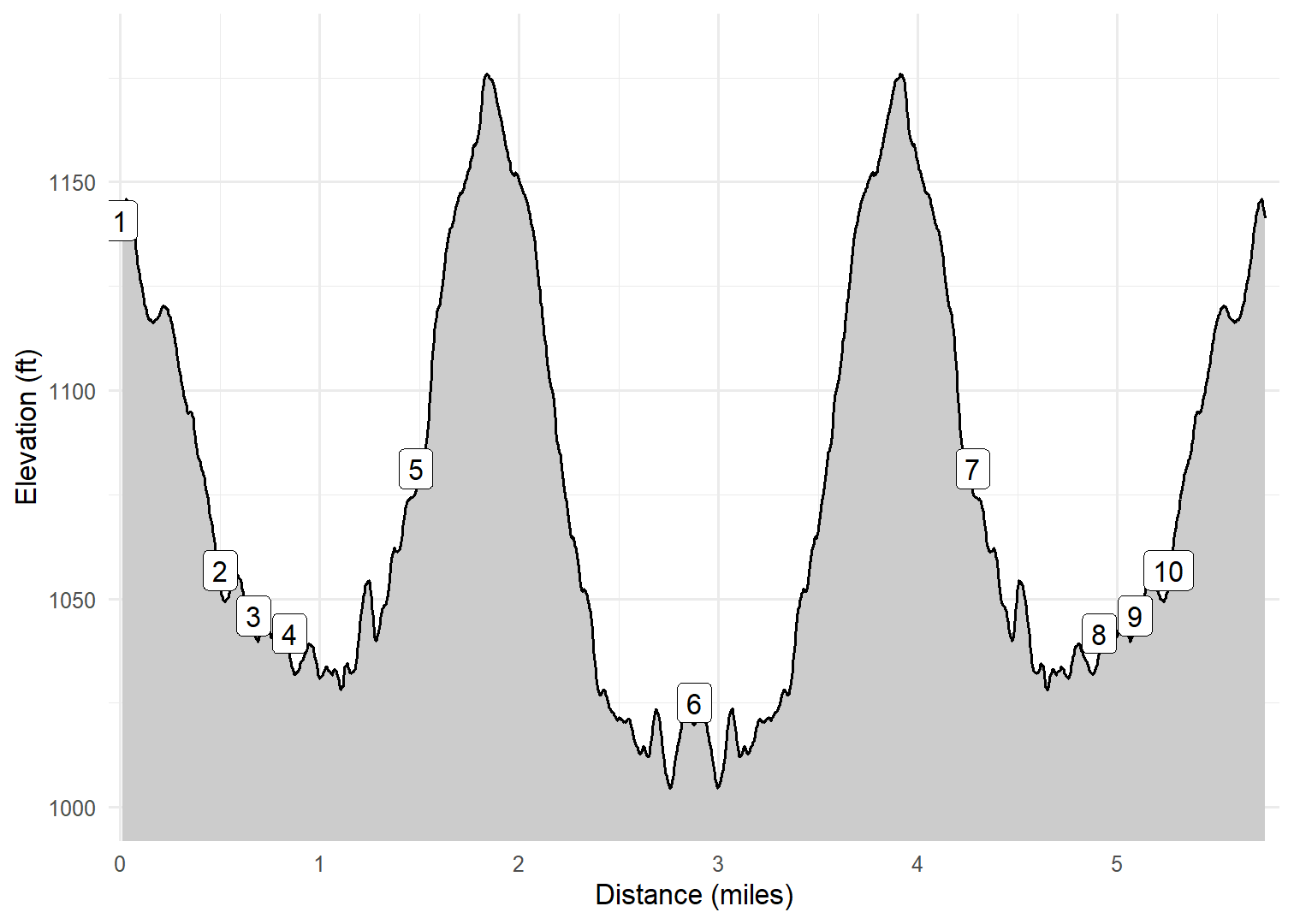
- Numeric labels correspond to the same labels in the elevation profile and summary information below.
Elevation Profile
Images

BBNGR01: Typical scenery in Winter 2023

BBNGR03: Balance Rock

BBNGR05: Typical scenery in Winter 2023

BBNGR05: Typical scenery in Winter 2023

BBNGR02: Cash near Richmond Springs
GPX Download
A sanitized GPX file of our hike is here.
Summary Information
| NUM | trackID | Primary | Description | Type | Owner | Distance | CumDist | DeltaElev |
|---|---|---|---|---|---|---|---|---|
| 1 | BBNGR01 | Backbone SP - North Gate Rd | North Gate to Richmond Springs trail | Paved | Public | 0.50 | 0.50 | -84 |
| 2 | BBNGR02 | Backbone SP - North Gate Rd | Richmond Springs trail to Barred Owl trail [North] | Paved | Public | 0.17 | 0.67 | -11 |
| 3 | BBNGR03 | Backbone SP - North Gate Rd | Barred Owl trail [North] to Cave trail | Paved | Public | 0.18 | 0.85 | -4 |
| 4 | BBNGR04 | Backbone SP - North Gate Rd | Cave trail to Barred Owl trail [South] | Paved | Public | 0.63 | 1.48 | 40 |
| 5 | BBNGR05 | Backbone SP - North Gate Rd | Barred Owl trail [South] to South Flats trail | Paved | Public | 1.40 | 2.88 | -56 |
| 6 | BBNGR05 | Backbone SP - North Gate Rd | South Flats trail to Barred Owl trail [South] | Paved | Public | 1.40 | 4.28 | 56 |
| 7 | BBNGR04 | Backbone SP - North Gate Rd | Barred Owl trail [South] to Cave trail | Paved | Public | 0.63 | 4.91 | -40 |
| 8 | BBNGR03 | Backbone SP - North Gate Rd | Cave trail to Barred Owl trail [North] | Paved | Public | 0.18 | 5.09 | 4 |
| 9 | BBNGR02 | Backbone SP - North Gate Rd | Barred Owl trail [North] to Richmond Springs trail | Paved | Public | 0.17 | 5.26 | 11 |
| 10 | BBNGR01 | Backbone SP - North Gate Rd | Richmond Springs trail to North Gate | Paved | Public | 0.50 | 5.76 | 84 |